The Map Gallery

Welcome to the Ohio Valley Chapter's Virtual Gallery! This gallery highlights the exceptional work being done by geospatial professionals and students across Ohio, West Virginia, and Western Pennsylvania.
From innovative mapping solutions to powerful data visualizations, these submissions demonstrate the real-world impact and technical excellence that define our profession. We're proud to provide a platform that showcases the meaningful contributions our community makes every day—whether solving complex spatial problems, supporting critical decision-making, or advancing the science and practice of GIS.
Explore the gallery below to see how our regional geospatial community is shaping the future of the profession.
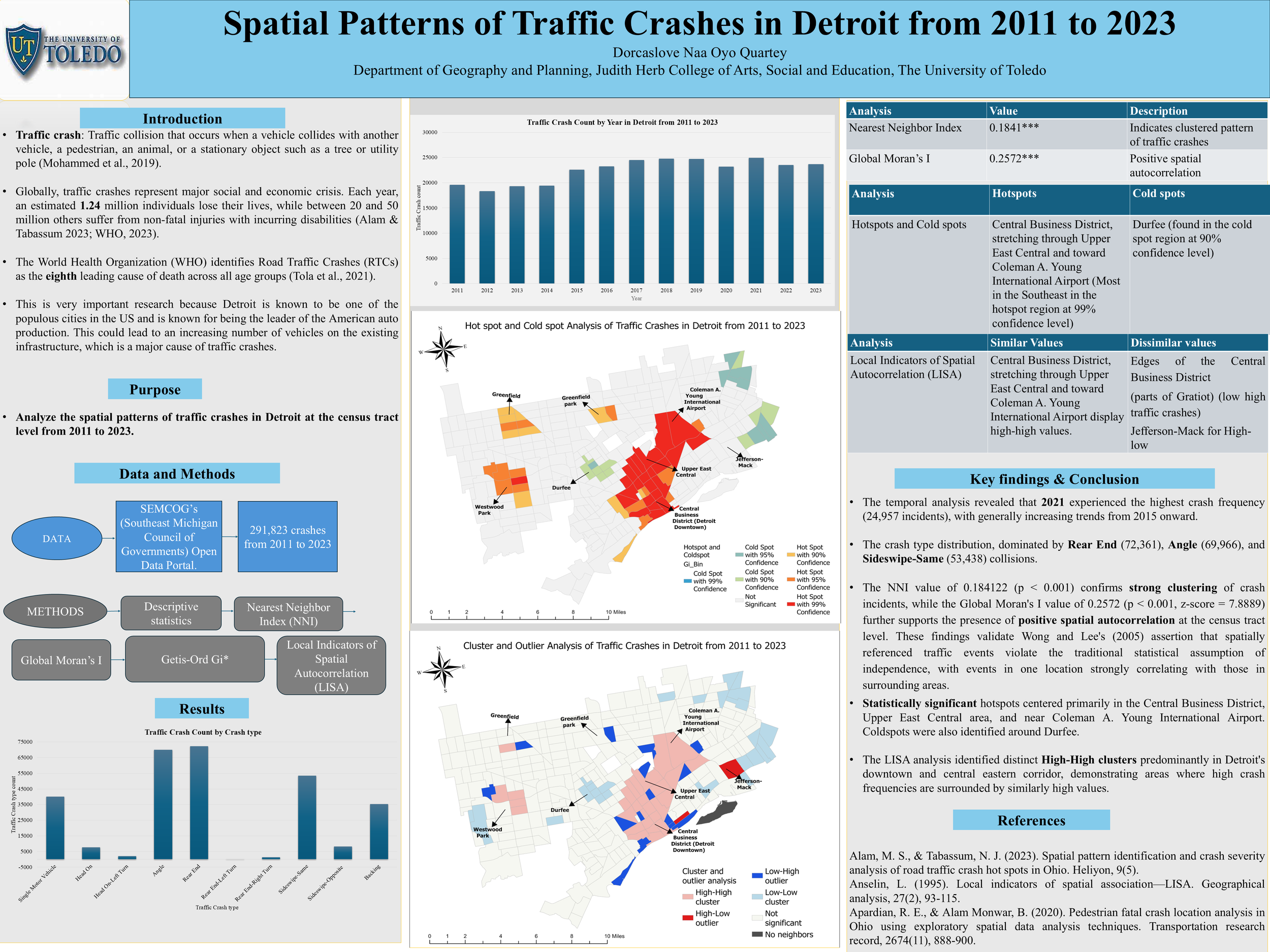
Spatial Patterns of Traffic Crashes in Detroit from 2011 to 2023
By Dorcaslove Naa Oyo Quartey, University of Toledo
Traffic crashes are a critical global public health issue, claiming approximately 1.24 million lives annually and causing 20 to 50 million non-fatal injuries. The World Health Organization ranks road traffic crashes as the eighth leading cause of death across all age groups.
Detroit presents a compelling case for crash analysis as one of the most populous U.S. cities and the historic center of American automobile production. The city's automotive legacy has resulted in substantial vehicle presence on existing infrastructure, potentially elevating crash risk.
This study examines spatial patterns of traffic crashes in Detroit at the census tract level from 2011 to 2023, analyzing 291,823 incidents from the Southeast Michigan Council of Governments Open Data Portal.
Using spatial analysis techniques including Nearest Neighbor Index, Global Moran's I, Getis-Ord Gi*, and LISA, this research identifies clustering patterns and hotspots to guide traffic safety improvements and urban planning in Detroit.
Union County, PA Historical Sites
Pierce Feite, Union Co GIS Intern, Bloomsburg University
Union County, Pennsylvania, established in 1813, sits at the heart of the state’s rich agricultural and cultural heritage. Formed from parts of Northumberland County, it developed around small towns, fertile farmland, and the West Branch of the Susquehanna River.
This Area supported early industry, trade, and settlement. Lewisburg, the county seat, grew into a vibrant center of education and commerce. It would go on to become home to Bucknell University and a well-preserved historic district. Across the county, visitors can find numerous historical sites that reflect its early American roots, including the iconic Dale/Engle/Walker House, the rich collections of the Packwood House Museum, the historic iron furnaces and mills that once powered local industry, and a variety of 19th-century churches, farms, and covered bridges.
Together, these places help tell the story of a county shaped by frontier-era settlement, agricultural tradition, and a deep commitment to preserving its past.
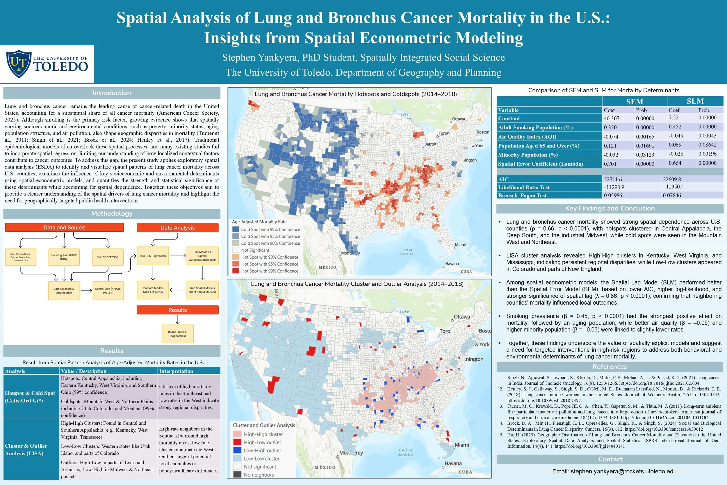
Spatial Analysis of Lung and Bronchus Cancer Mortality in the U.S.:
Insights from Spatial Econometric Modeling
By Stephen Yankyera, PhD Student, University of Toledo
Lung and bronchus cancer remains the leading cause of cancer-related deaths in the United States, accounting for a significant proportion of overall cancer mortality. While smoking is widely recognized as the primary risk factor, recent research highlights the influence of spatially varying socioeconomic and environmental conditions on mortality patterns. Factors such as poverty, minority status, aging populations, and air pollution contribute to geographic disparities in lung cancer outcomes.
Traditional epidemiological models often fail to capture these spatial processes, limiting our understanding of localized contextual factors.
Spatial econometric modeling offers a powerful approach to address this gap by incorporating spatial dependencies and heterogeneity into analysis. This method enables researchers to identify clusters of high mortality and assess the role of neighborhood-level characteristics in shaping health outcomes.
By applying spatial analysis to lung and bronchus cancer mortality, this study seeks to provide insights into the complex interplay between environmental exposures, social determinants, and geographic patterns of disease. Such findings can inform targeted interventions and policy strategies aimed at reducing disparities and improving public health outcomes.
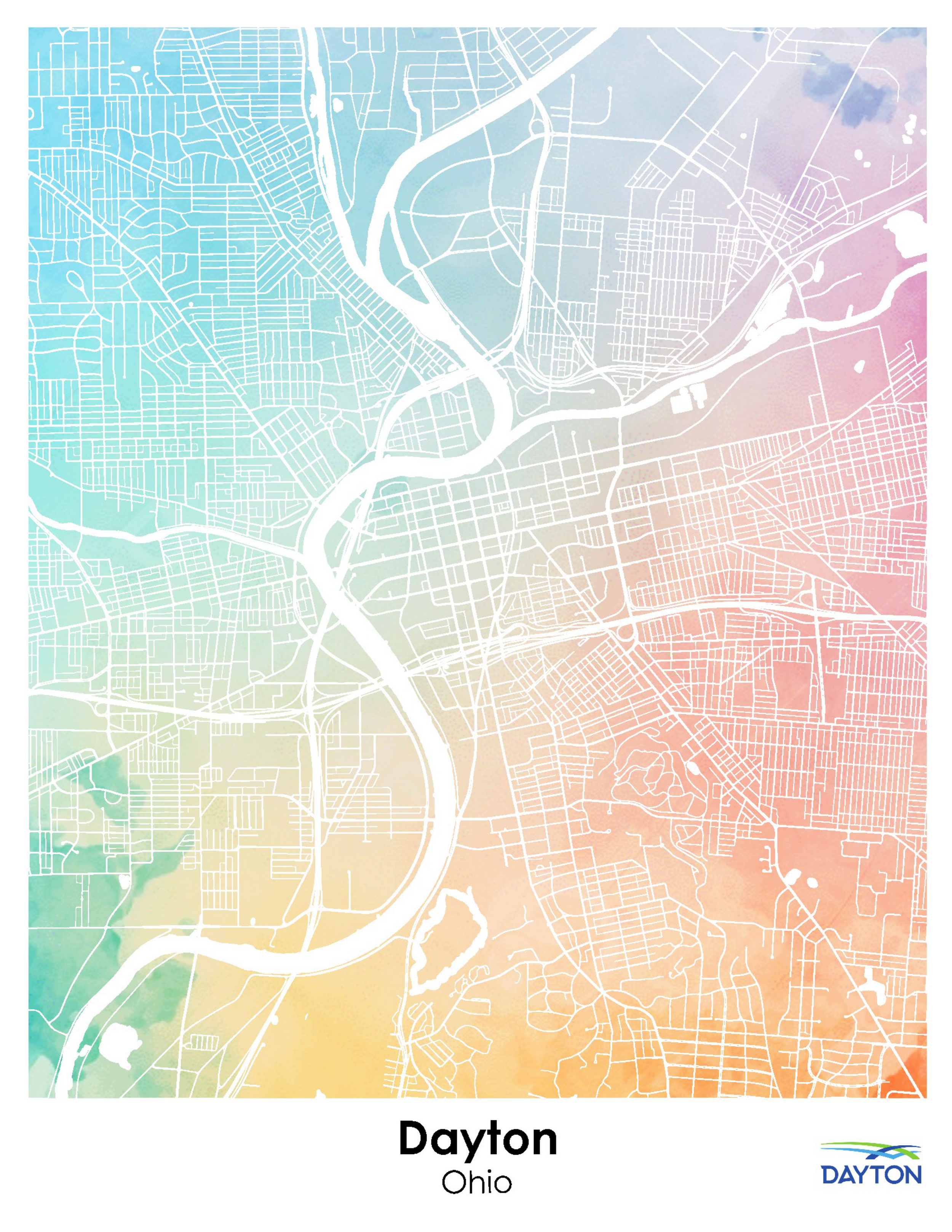
Dayton Watercolor
By Cameron Goschinski, Miami University
Designed and inspired by the art style of Emily Garfield.
When most people think of GIS and mapping, they picture data layers, analysis tools, and precise spatial models. And while that’s all true, maps have always been more than technical documents — they are expressions of place, perspective, and creativity. Cartography has long stood at the intersection of science and art, transforming geographic information into something not only informative, but visually compelling.
This watercolor map of Dayton is a reminder that mapping isn’t limited to numbers and boundaries. It can highlight the character of a city, evoke emotion, and capture the essence of a landscape in ways data alone cannot. Whether created through traditional brushwork or digital tools, artistic maps invite us to experience geography differently — to see cities not just as coordinates and parcels, but as vibrant, living places shaped by culture, memory, and imagination.
In Dayton’s case, this artistic interpretation reflects both the spirit of the city and the creativity inherent in the mapping profession. GIS may help us understand how a place works, but artistic mapping helps us remember why it matters.
CODE, CRIME AND CONDITION:
What do property grades and their correlates reveal about the City of Logan?
By Sydney Roseberry, Ohio University
Nestled in the hills of Appalachian Ohio, the City of Logan stands as a vibrant community of approximately 7,000 residents and serves as the county seat and largest municipality in Hocking County. As a regional anchor for Central Ohio's smaller urban areas, Logan represents both the opportunities and challenges facing rural American cities today. The community confronts significant obstacles including workforce displacement, housing instability, and constrained state resources—issues that intensify the city's already limited capacity for development and social services.
In response to these challenges, Logan must strategically prioritize investments that deliver multiple benefits: economic sustainability, job creation, and preservation of the city's distinctive historical character. This project employs spatial correlational analysis to examine the relationships between property conditions and key urban indicators throughout Logan. By mapping and analyzing these patterns, we aim to identify opportunities for strategic development that will strengthen the community's economic foundation while honoring its heritage and addressing the needs of its residents.